
A new vision for intercity transit in BC

I've always wanted to crayon a intercity bus system for BC. As someone who doesn't have a license, getting between cities here is way harder than it needs to be. On a recent trip to Trondheim, Norway, I was inspired by their comprehensive intercity bus system for a similarly sparse province. In this article, I will lay out the pieces to create an intercity public transit network in BC.
Why don't we have one already?
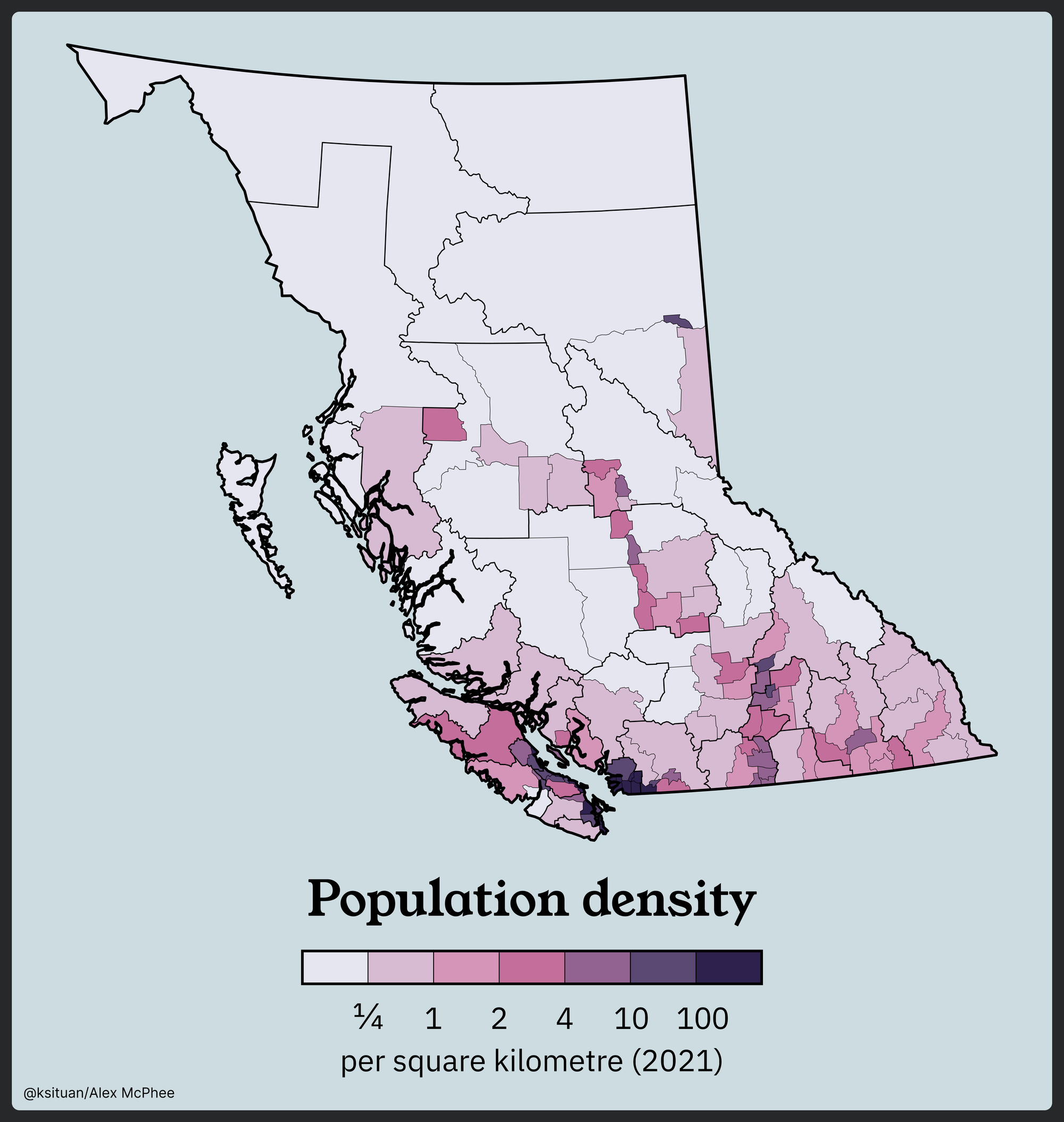
BC is unlike many populated places in the world with its geography: smaller population centres are spread out over a province filled with mountains and forests. Compare BC to another province like Ontario or Québec, or a region like Central Europe where large cities and towns are laid out in straight lines over farmland.
Of course none of this makes building an intercity transit network impossible, but it raises the bar for implementation, requiring more inertia to get a proper network off the ground.
Looking at a population density map however, you can see that there are nice some linear corridors that we can take advantage of. Additionally, these corridors follow existing highways. Good examples of this are the Highway 1/19 corridor between Victoria and Courtney/Comox, and the Highway 97 corridor in the Okanagan. North of Kamloops, Highway 97 becomes of one of the only clusters of density in the north half of the province, along with Highway 16.
Trains or buses?
Buses often get forgotten when it comes to intercity or regional travel. Most people tend to think of trains when it comes to longer trips, but just like in urban transit, buses can be the secret workhorse of a system. Buses are extremely flexible, require little to no new infrastructure, and can be easily scaled up or down to meet demand.
In the case of intercity transit in BC, buses have two secret superpowers over trains:
- Density in BC rarely strays far from highways
- Buses don't have many stops to make, making them more time-competitive with driving.
Of course like any other urbanist I love trains, but in our case I believe the best move is to start running buses as soon as we can. In Vancouver we have a history of building transit ridership with buses to justify rail expansion, and we should continue this practice with our intercity and regional transit as well.
What do we have to work with?
BC actually already has a surprisingly good intercity "public" "transit" network... if you want to cross a body of water. BC Ferries runs routes all over coastal BC, including between our two most important cities – Vancouver and Victoria. BC Ferries also serves other important destinations, such as Nanaimo, Powell River, the Sunshine Coast and Prince Rupert. Additionally, they provide lifeline service to smaller indigenous communities, such as Ocean Falls, Klemtu, Haida Gwaii and Penelakut Island. Almost all of the places served by BC Ferries are only accessible by boat or plane, so including them in a vision for intercity transit is essential. Unfortunately BC Ferries has a notorious reputation in BC, stemming from a whole host of problems which is a topic for another day.
The province actually does operate public intercity bus service in the north under the brand "BC Bus North", between places such as Prince Rupert, Fort Nelson, Dawson Creek and Prince George. Service was introduced here as the highways in the north have become notorious for being extremely dangerous for hitchhikers. Highway 16 - which runs between Prince Rupert and Fort Nelson – was even dubbed the Highway of Tears for its history of violence. As many people in these communities cannot or do not drive, this service was introduced as a public safety measure. However, the service here is bare minimum and intended for people who don't have any other choice.
In some communities, BC Transit provides regional and intercity bus service. The most successful example of this is the 66 FVX, which connects Metro Vancouver with Abbotsford and Chilliwack. The 66 is regularly overcrowded and often leaves people behind. Other examples include the (other) 66 connecting Victoria and Duncan, the 90 connecting Vernon and Kelowna, and the 11 connecting Terrace and Kitimat. However, service on these routes is usually very limited, and is mostly commuter-oriented.
Finally, private bus companies provide the only bus service between many cities. While service can be good, private bus companies rely on market forces to provide service, meaning they can have high fares, fail to serve communities that would be unprofitable, lack a cohesive network and branding, and can disappear at any time – like Greyhound did in 2021 when it pulled out of Canada completely. Below is a visualization of some of the existing private intercity bus services in BC by u/bcl15005.
Visualization of most long-distance bus services in BC, with some ferry routes thrown in for good measure
by u/bcl15005 in britishcolumbia
Who's responsibility is it?
A quick rundown on transit jurisdiction
- The province is responsible for:
- capital funding
- operating funding (for BC Transit only)
- provincial highways and roadways
- BC Ferries (kinda)
- Regional districts (if you don't know what that is) are responsible for:
- operating funding*
- Municipalities are responsible for:
- capital funding
- operating funding
- local infrastructure and roadways
- BC Transit is responsible for:
- service planning
- service operation
*Regional districts are weird, and where there are no municipalities, they can assume the responsibilities. Certain regional districts like Nanaimo and the Sunshine Coast actually directly operate service instead of contracting operations out.
There's exceptions to all of these rules, especially when it comes to TransLink, this is more meant as a generalization.
What?
Yeah – it's a mess. You may notice that "operating funding" is listed under three levels of government. How do they decide who pays for what and how much? Well that can be a total mess and it can involve cost sharing agreements.
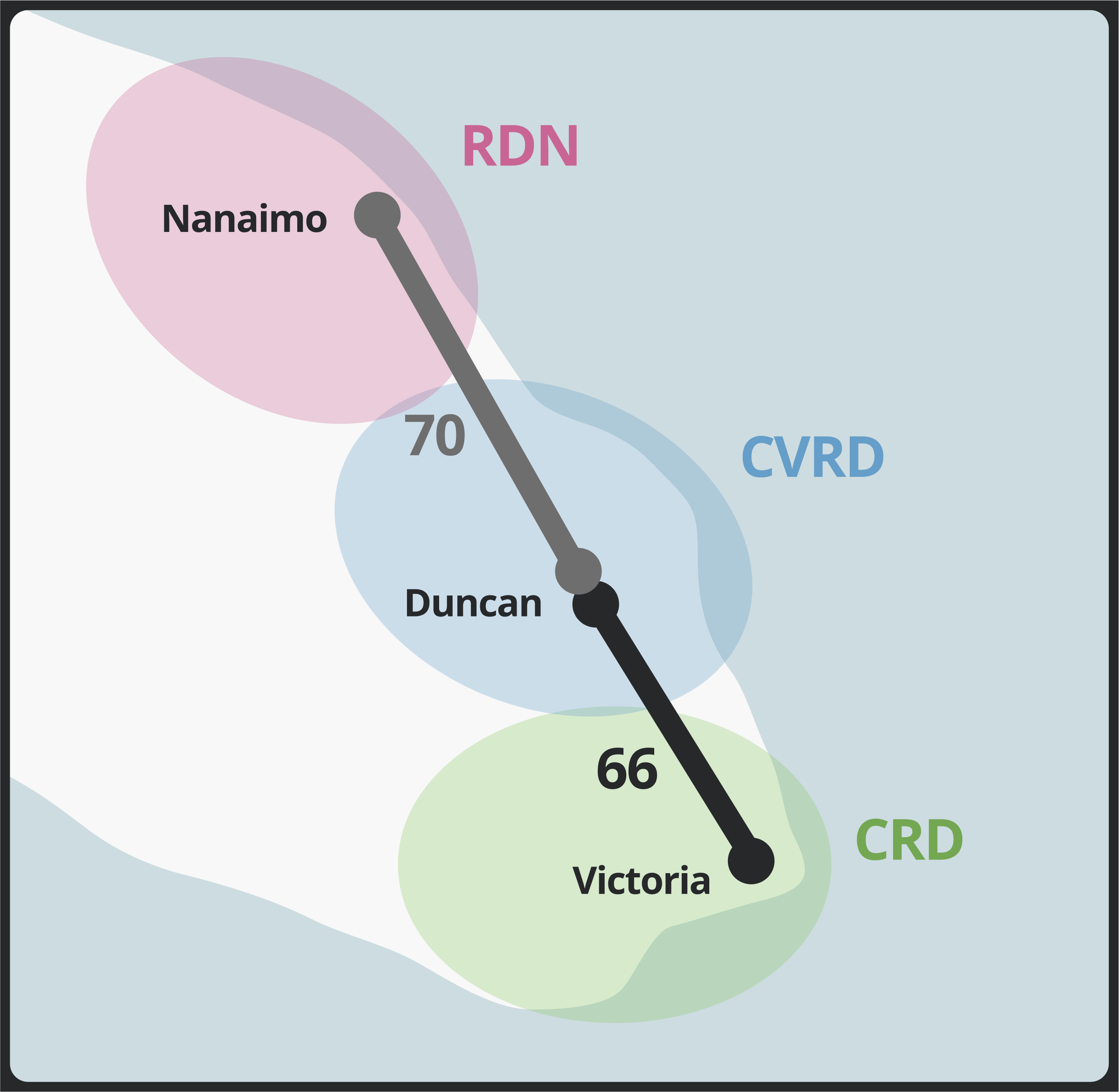
Take Route 66 Cowichan Valley Express (CVX) in the Cowichan Valley system, connecting Victoria and Duncan. From Duncan, you can catch Route 70 Nanaimo–Cowichan Express (NCX) to Nanaimo. This means technically, it is possible to take a public bus between Victoria and Nanaimo. However, these routes only run a handful of times during the day.
If you wanted to improve these services, you'd have to coordinate between 3 regional districts: the Capital Regional District (Victoria), the Cowichan Valley Regional District, and the Regional District of Nanaimo. Current efforts to increase service on the 66 CVX have stalled because both the CVRD and the CRD want the other (or the province) to pay for the service increase.
“I think we all recognize that using local property taxes aren’t the best way to fund transit”
- Aaron Stone, chair of the Cowichan Valley Regional District
The province can bypass this mess.
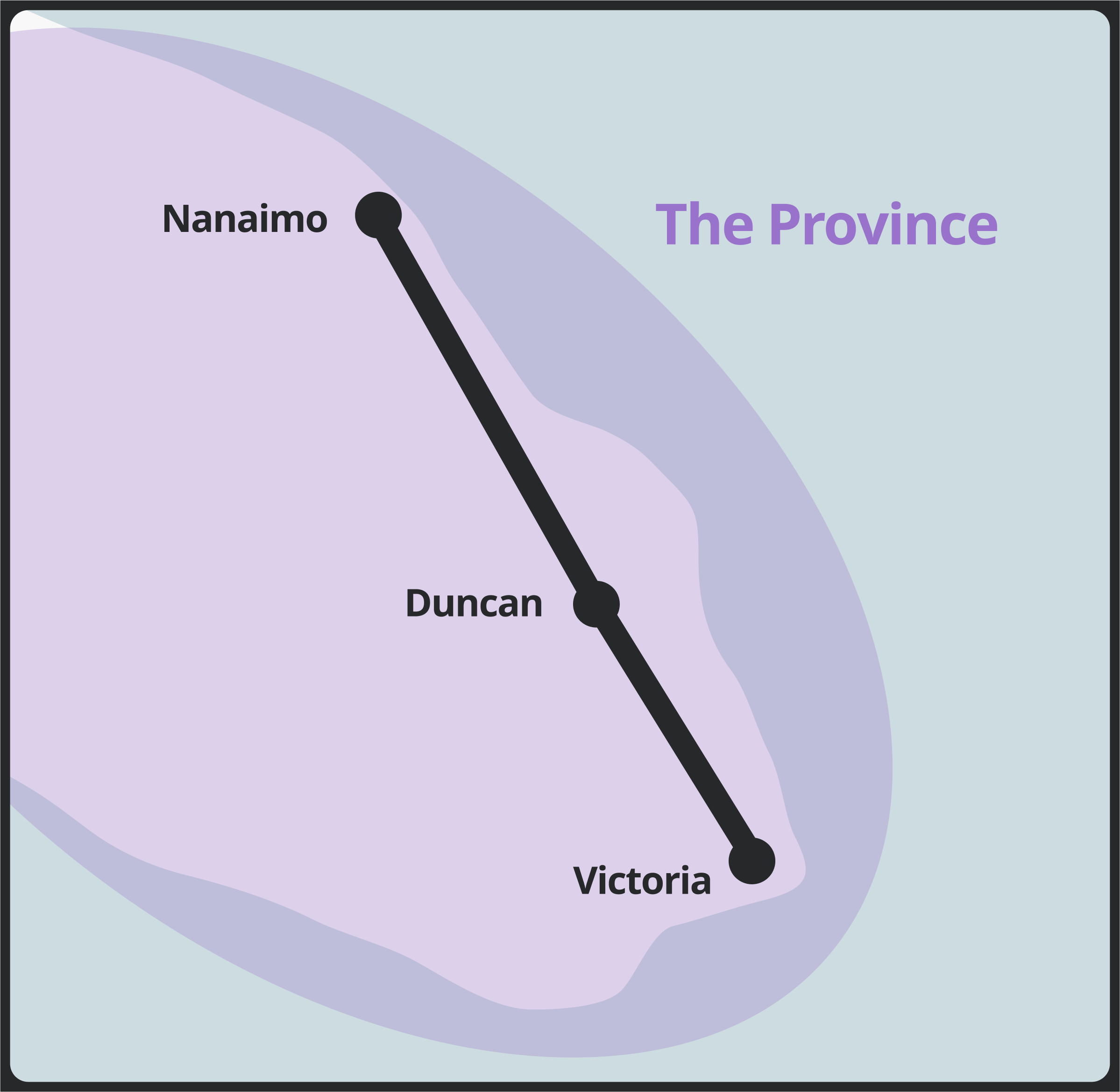
An intercity bus network needs to be the responsibility of the province. Instead of letting regional districts negotiate with each other over planning and cost responsibility, the province could plan and operate the system itself. This would also remove funding pressure from regional districts and free up some resources to make much needed improvements to local service.
The province is already responsible for provincial roadway travel, overseeing a network of provincial highways and ferry routes. Intercity buses can be seen as an extension of this transportation network under provincial jurisdiction.
What could a network look like?
Show me the buses.
Five Systems
When thinking about a bus network, it's important to think about hubs. Where different lines start, end, and intersect. For passengers, it provides a location to transfer between lines. When operating intercity service, it provides a convenient location to locate operations and maintenance facilities.
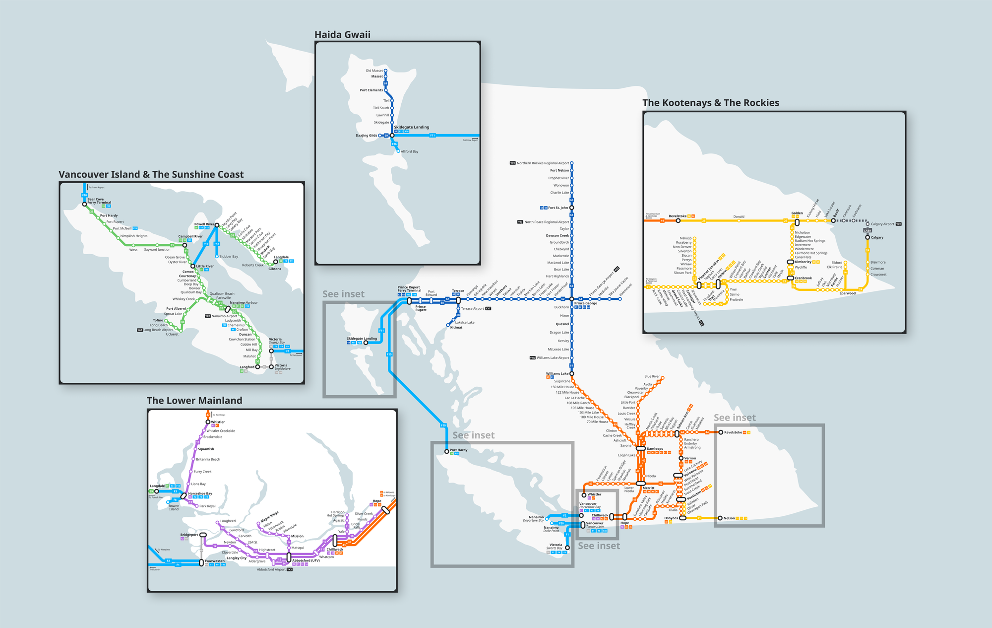
In BC, five natural hubs emerge anchoring their respective systems:
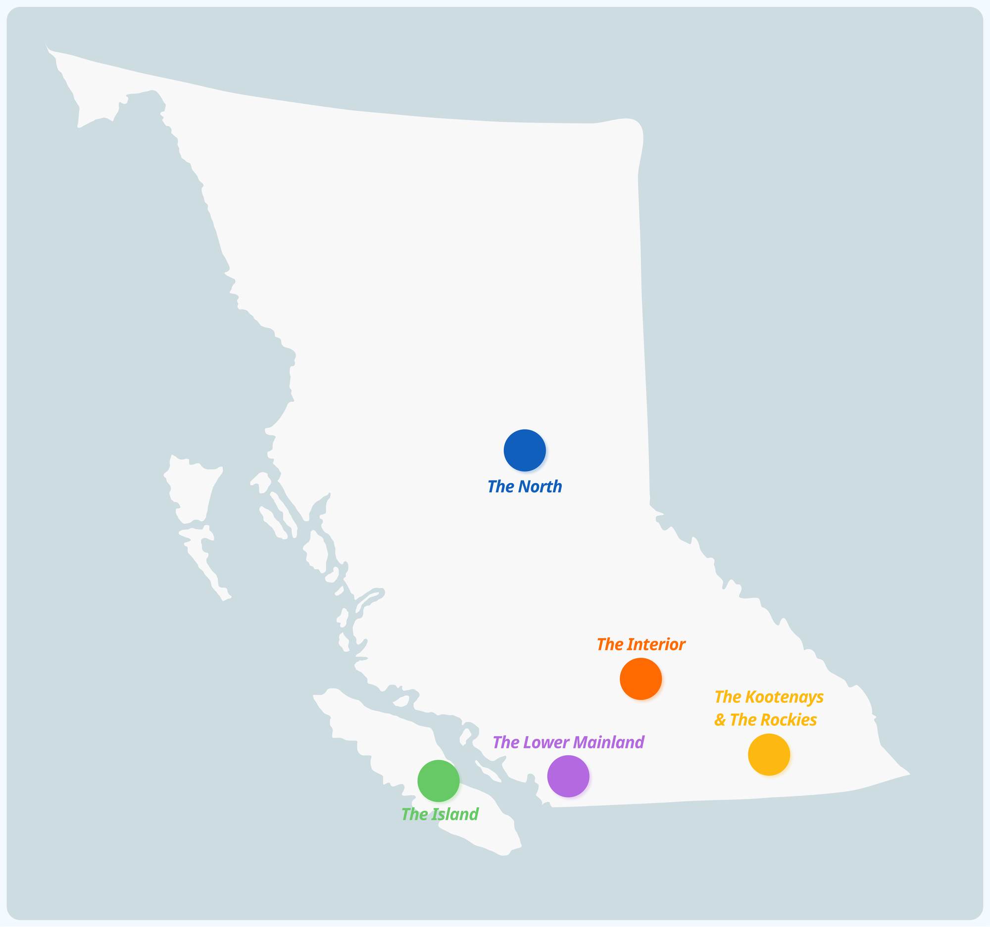
- Nanaimo, anchoring Vancouver Island
- Metro Vancouver, anchoring the Lower Mainland
- Kamloops, anchoring the Interior
- Nelson, anchoring the Kootenays
- Prince George, anchoring the North
Let's take a look at how each region could be laid out.
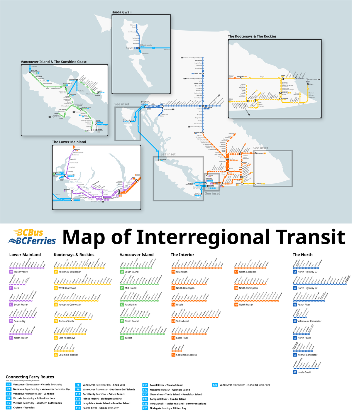
System 1: Vancouver Island and the Sunshine Coast
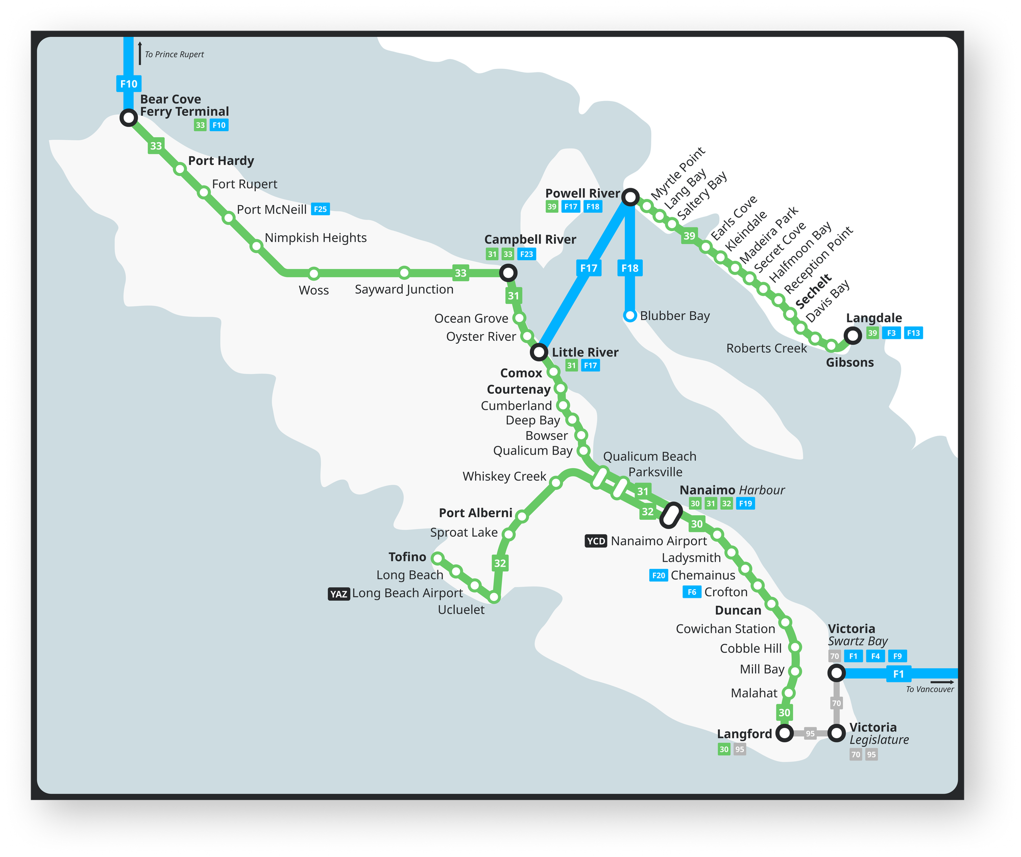
The proposed network would allow crossing the island end-to-end in three segments: Victoria to Nanaimo (Route 30), Nanaimo to Campbell River (Route 31), and Campbell River to Port Hardy (Route 33). Additional routes would connect Nanaimo with Tofino (Route 32) and traverse the Sunshine Coast (Route 39). Route 30 would replace BC Transit's Route 66 CVX and Route 70 NCX. Routes 31 and 39 would connect a patchwork of local transit networks which currently lack (consistent) service between them. Intercity bus routes would connect with various ferry terminals along the coast, with connections to Vancouver, the Sunshine Coast, Prince Rupert, and both the North and South Gulf Islands.
System 2: The Lower Mainland
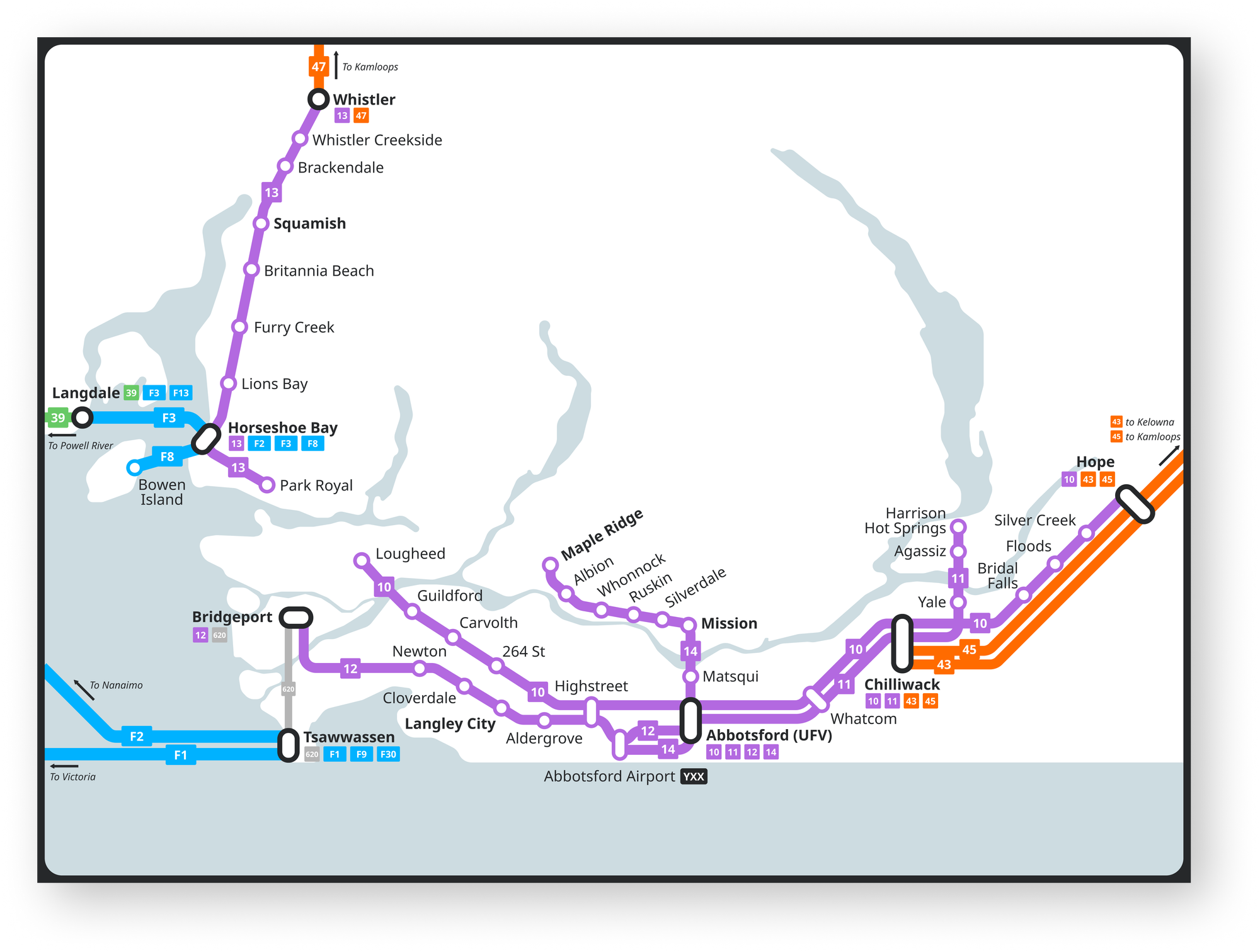
The proposed network would connect Metro Vancouver with the Fraser Valley (Routes 10, 12 and 14), provide service on the Sea-to-Sky corridor (Route 13), and create additional connections between Abbotsford, Chilliwack, Agassiz and Harrison Hot Springs (Route 11). Routes 10, 12, 13 and 14 would run with all day frequent service, offering free transfers to local transit. A handful of trips on Route 10 would extend to Hope, while most turn around in Chilliwack. Abbotsford Airport (YXX) would be served with all-day frequent regional routes to Maple Ridge and Bridgeport Canada Line Station, allowing speedy trips between Metro Vancouver and its second major airport.
System 3: The Interior
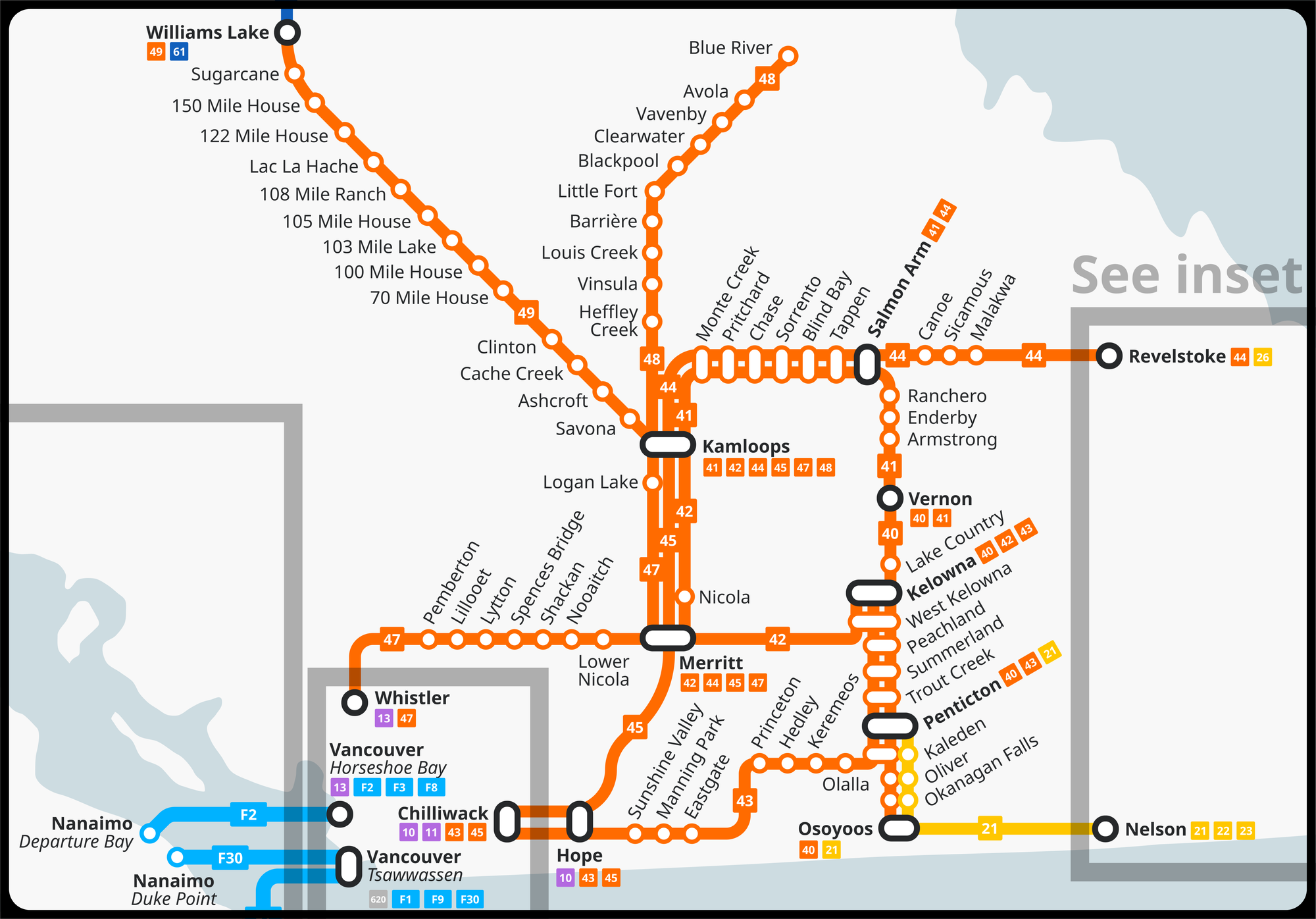
Three routes connect the Lower Mainland with the interior (Routes 43, 45 and 47), two routes link Kamloops and the Okanagan (Routes 41 and 42), two routes connect Kamloops to the north (Routes 48 and 49), and Route 44 connects Kamloops and the Rockies. Route 40 traverses the Okanagan, replacing a handful of intercity routes operated by BC Transit. Route 48 would also replace intercity service operated by BC Transit. Kamloops would operate as a main hub for the province's bus network, tying together The Lower Mainland, The Kootenays & The Rockies, and The North.
System 4: The Kootenays & The Rockies
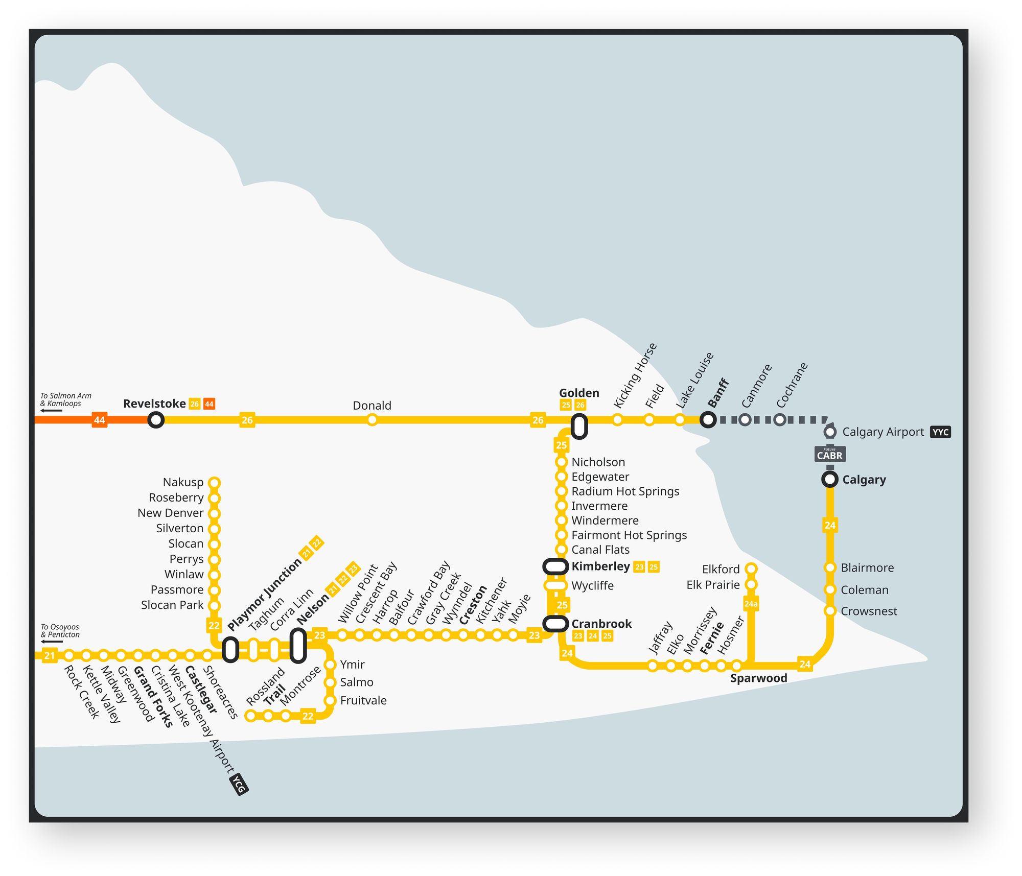
The system in this region would operate in a more polycentric fashion, with regional hubs in Cranbrook and Nelson. Routes out of Nelson would connect to Penticton and the Okanagan (Route 21), Nakusp and Trail (Route 22), as well as Cranbrook and Kimberley (Route 23). Routes out of Cranbrook would connect to Calgary (24) and Golden (Route 25). A limited branch of Route 24 (24a) would operate between Cranbrook and Elkford. Route 26 would run between Revelstoke and Banff, eventually connecting with the proposed Calgary–Banff rail line. These routes would replace a handful of intercity routes currently operated by BC Transit.
System 5: The North

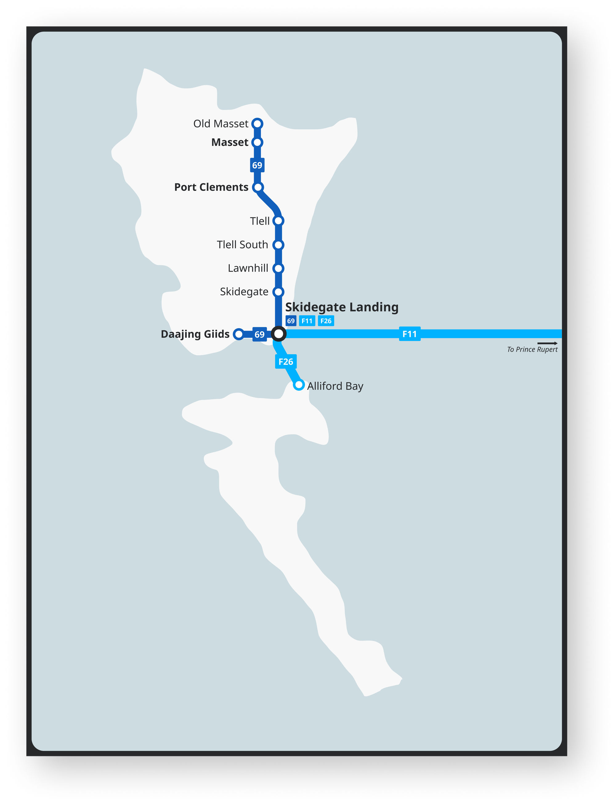
Most service in the North would operate with the same routings as the current BC Bus North service, albeit with improved service (Routes 61, 62, 63, 64, 66). Route 68 would provide additional service between Prince Rupert and Terrace, as well as connect Kitimat and replace the current BC Transit 11. Route 69 would traverse Graham Island, providing public transit service to Haida Gwaii for the first time.
Conclusion
As I am not a transportation planner, the routes in the map below are more meant to be demonstrative of how an intercity bus network could work in BC. Such a system would also need to be well integrated with local BC Transit services to allow residents and visitors to get to and from intercity routes.
If you would like to get involved to make it a reality, there is a group of British Columbians fighting for intercity bus service called BC-Wide Bus. Additionally, fighting specifically for better intercity service on Vancouver Island is Better Island Transit.
If you're curious what intercity service BC Transit operates currently, you can see them pretty clearly over at transit.land.